



At around 5,164 meters, Gorakshep is the last cluster of lodges before Everest Base Camp. Trekkers arrive, sleep badly, and leave at dawn. Few of them think about what the buildings are standing on. Beneath much of the terrain above roughly 5,000 meters in the Khumbu lies frozen ground, and that ground is warming. Permafrost degradation in the Everest region is harder to see than a retreating glacier, but it reshapes slopes, loosens rock walls, and quietly undermines the trails, bridges and lodges that the Khumbu economy depends on. Here is what the measurements actually show, what remains uncertain, and why the science matters to anyone who lives or walks at this altitude.
What Permafrost Is, and Why It Is Not the Same as Glacier Ice
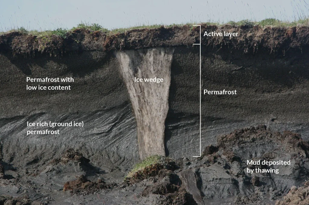
Permafrost is ground that stays at or below 0 degrees Celsius for at least two consecutive years. It is defined by temperature, not by ice content. Some permafrost is rock with ice filling its cracks. Other permafrost is loose debris cemented by ice into a solid mass.
Glacier ice sits on the surface and you can photograph it. Frozen ground sits underneath and you generally cannot. That difference explains why Himalayan permafrost has been studied far less than Himalayan glaciers, even though it covers a much larger area across the Hindu Kush Himalaya.


A useful shorthand in the literature is the lower limit of permafrost, or LLP: the elevation below which frozen ground no longer persists year round. When air temperatures rise, that limit climbs the mountain. Everything between the old limit and the new one is ground that used to be frozen and is not any more.
The Active Layer
Above permafrost sits the active layer, a surface zone that thaws each summer and refreezes each winter. As the climate warms, the active layer deepens. Water moves into cracks that used to be sealed by ice. Freeze and thaw cycles work on them. Over years, this weakens rock faces and debris slopes in ways that are invisible until something falls.
The Measurements From the Khumbu
Nepal has one of the longer records of high-altitude ground temperature work in the Himalaya, though it is still thin by Alpine or Arctic standards. Japanese teams measured ground temperatures in the Khumbu as early as 1973 and concluded that permafrost was present above roughly 4,900 to 5,000 meters.
Later work revised that picture upward. A review of periglacial research in the Nepal Himalaya, published in the Nepal Journal of Environmental Science, summarizes the key dataset: Fukui and colleagues tracked the lower permafrost limit in the Khumbu from 1973 to 2004 using ground temperatures measured at 50 centimeters depth. They reported a limit of 5,200 to 5,300 meters in 1973, a rise of 100 to 300 meters by 1991, and relative stability at 5,400 to 5,500 meters through the following decade.
Put plainly: a belt of terrain roughly 200 to 300 meters thick, wrapped around the valleys of the Khumbu, appears to have crossed from permanently frozen to seasonally thawed within one human generation.
Other elevations recorded across Nepal show how much the limit varies by region and aspect:
| Area | Reported lower limit of permafrost (m asl) | Source cited in review |
|---|---|---|
| Khumbu Himal (1973) | 5,200 to 5,300 | Fukui et al. (2007) |
| Khumbu Himal (post-1991) | 5,400 to 5,500 | Fukui et al. (2007) |
| Gokyo valley (rock glacier based) | about 5,150 | Mayer et al. (2012) |
| Kanchenjunga, south and east facing | about 5,300 | Ishikawa et al. (2001) |
| Kanchenjunga, north facing | about 4,800 | Ishikawa et al. (2001) |
| Annapurna Himal | 4,450 to 5,120 | Regmi (2008) |
| Langtang Himal | 4,600 to 4,920 | Regmi (2008) |
Note the Kanchenjunga contrast. On the same massif, slopes facing the sun hold permafrost only 500 meters higher than shaded slopes do. Aspect matters enormously, which is why a single number for “the permafrost line” is always a simplification.
How Confident Should We Be?
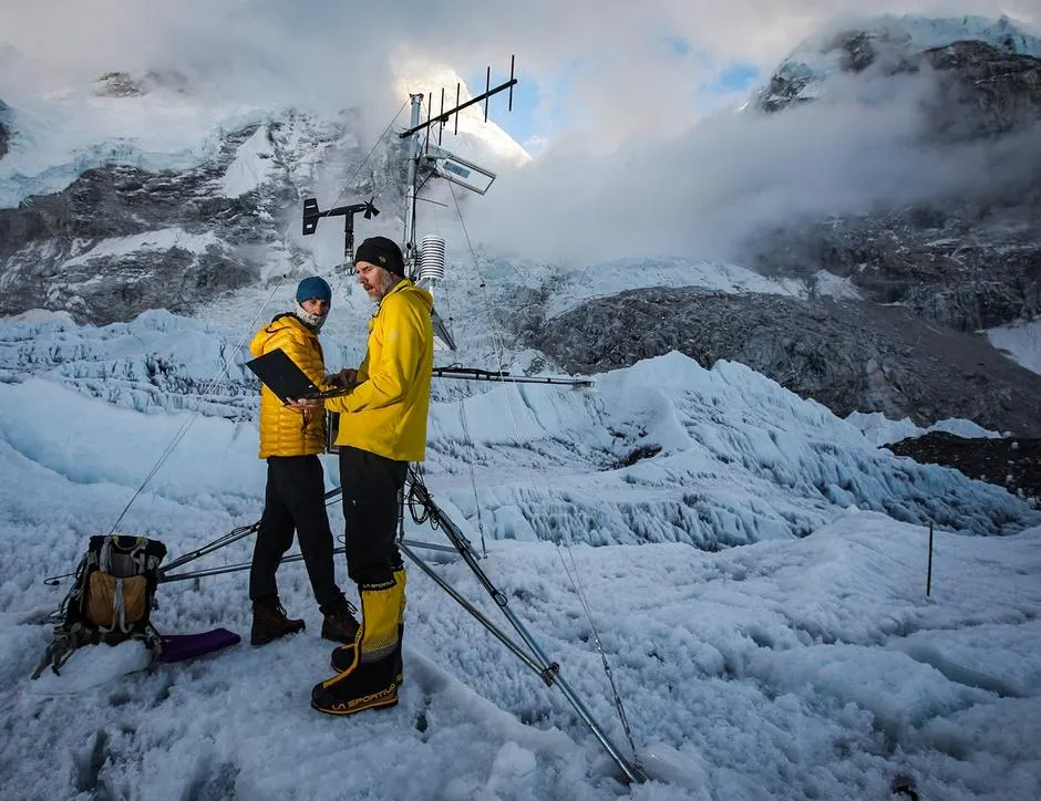
Less confident than the tidy numbers suggest. Nepal has almost no long-term borehole monitoring of ground temperature at these elevations. Most estimates are inferred: from shallow ground temperature, from electrical resistivity surveys, from seismic refraction, or from mapping rock glaciers and working backward to the climate conditions that sustain them.
Weather stations above 5,000 meters are rare and their records are short. Researchers have repeatedly flagged that climate trends at these elevations in Nepal are poorly constrained. The review cited above gives a rate of rise for the permafrost limit of 1.3 to 2.6 meters per year, but readers should treat that as an estimate derived from sparse data rather than a measured, continuous trend. Modeled permafrost maps for the Hindu Kush Himalaya exist, and comparisons against mapped rock glaciers have shown meaningful disagreement between models and observations.
Rock Glaciers: The Visible Evidence
Where you cannot see permafrost directly, you can often see a rock glacier. Rock glaciers are slow-moving tongues of ice-cemented debris, creeping downslope at centimeters to meters per year. Their presence is strong evidence that ice exists in the ground beneath.
Active rock glaciers have been documented in the Khumbu since the early 1990s, when seismic refraction work on one of them estimated permafrost between 5,000 and 5,300 meters. Across Nepal, rock glaciers tend to be larger in the east and smaller toward the west, following the same east-to-west gradient as the permafrost limit itself.
Rock glaciers also hold water. In a region where seasonal snow is declining and glacier mass is shrinking, ice locked in debris may become a proportionally more important store. Quantifying that store across Nepal remains an open research problem, and anyone offering a precise national figure is extrapolating.
The Infrastructure Problem
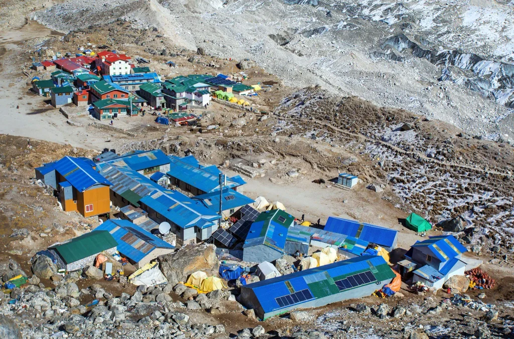
Khumbu tourism infrastructure is concentrated in exactly the elevation band where frozen ground is in transition. Lodges, trails, suspension bridges, helipads, water pipes and micro-hydro channels sit on moraine, on talus, and on slopes that were stabilized in part by ice.
A 2026 study in the journal Earth by Sapkota and colleagues mapped landslide risk across Sagarmatha National Park and set it against tourism infrastructure. Working from an inventory of 680 mapped landslides over about 659 square kilometers of snow-free and glacier-free terrain, they modeled hazard with three statistical approaches, the best of which reached 91 percent prediction accuracy.
Their exposure findings are the useful part for anyone managing the region:
- Around 641 buildings and 32 settlements fall within elevated-risk zones, including Pangboche, Thame and Thore.
- Roughly two-thirds of mapped bridges sit in high-hazard terrain.
- About half of mapped religious sites sit in high-hazard terrain.
- Approximately 147 kilometers of trekking route lie in high-exposure zones, with a small fraction crossing active landslide scars directly.
- Land surface temperature emerged as the single strongest predictor in the best-performing model, ahead of elevation and rainfall.
One caveat, stated plainly because it affects how the percentages should be read: the published paper reports two different totals for trekking route length in different sections, 678.88 km and 521.34 km, and does not reconcile them. Absolute kilometers in high-exposure zones are solid. Percentages derived from them are not, and we are not repeating them here as though they were.
The authors connect the strong temperature signal to probable permafrost degradation and slope thaw. That is a reasonable inference rather than a direct measurement. No one has instrumented those specific slopes to confirm that ice loss is the mechanism.
Why Frozen Ground Holds Slopes Together
Ice in a debris slope acts like cement. Remove it and you are left with loose rock at an angle it cannot sustain. In steep bedrock, ice in fractures does something similar, binding blocks that are otherwise held only by friction.
Warming does not cause failure on a schedule. It lowers the threshold. A rainfall event, an earthquake, or a season of unusual heat that would once have passed harmlessly can then trigger movement. Attributing any single rockfall to permafrost thaw is therefore difficult, and researchers generally avoid doing so without site evidence.
What Has Actually Gone Wrong in the Khumbu
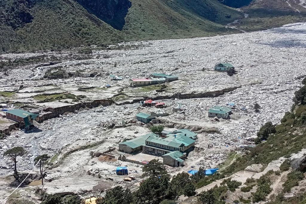
The clearest recent damage in the region came from water, not from thawing rock. On 16 August 2024, a glacial lake outburst flood struck Thame village in Solukhumbu. According to ICIMOD, which investigated the event and published a report on it in 2025, a disturbance entered an upper lake roughly 10 kilometers above the village, which overtopped its moraine and caused a second, lower lake to fail in sequence.
Fourteen properties were destroyed: seven homes, five hotels, a school and a health post. Around 135 people were displaced, including 40 children. No deaths were reported, largely because the flood arrived in daytime and many residents were away in Kathmandu or at the Namche market.
Thame is a glacial lake story rather than a permafrost story, and conflating the two would be sloppy. Still, both belong to the same family of problems: ice that used to be stable is now in motion, and settlements built when it was stable are exposed.
The Wider Cryosphere Context
Permafrost cannot be separated from what is happening to ice above it. ICIMOD’s 2026 assessment of Hindu Kush Himalaya glaciers found that ice loss rates have roughly doubled since 2000, that glaciers lost about 12 percent of their area and 9 percent of estimated ice reserves between 1990 and 2020, and that about 78 percent of glacier area in the region sits between 4,500 and 6,000 meters, the band most exposed to elevation-dependent warming.
That is the same band where permafrost lives. Glacier retreat also exposes fresh rock walls that were buttressed by ice, which is a known mechanism for increased rockfall in deglaciating mountains worldwide. You can see this interaction on the trek to Base Camp, where the Khumbu Glacier’s lateral moraines tower over the trail.
For a closer look at how fast the ice on Nepal’s highest peaks is changing, see our feature on glacial retreat across Nepal’s 8,000-meter peaks.
What Would Reduce the Risk
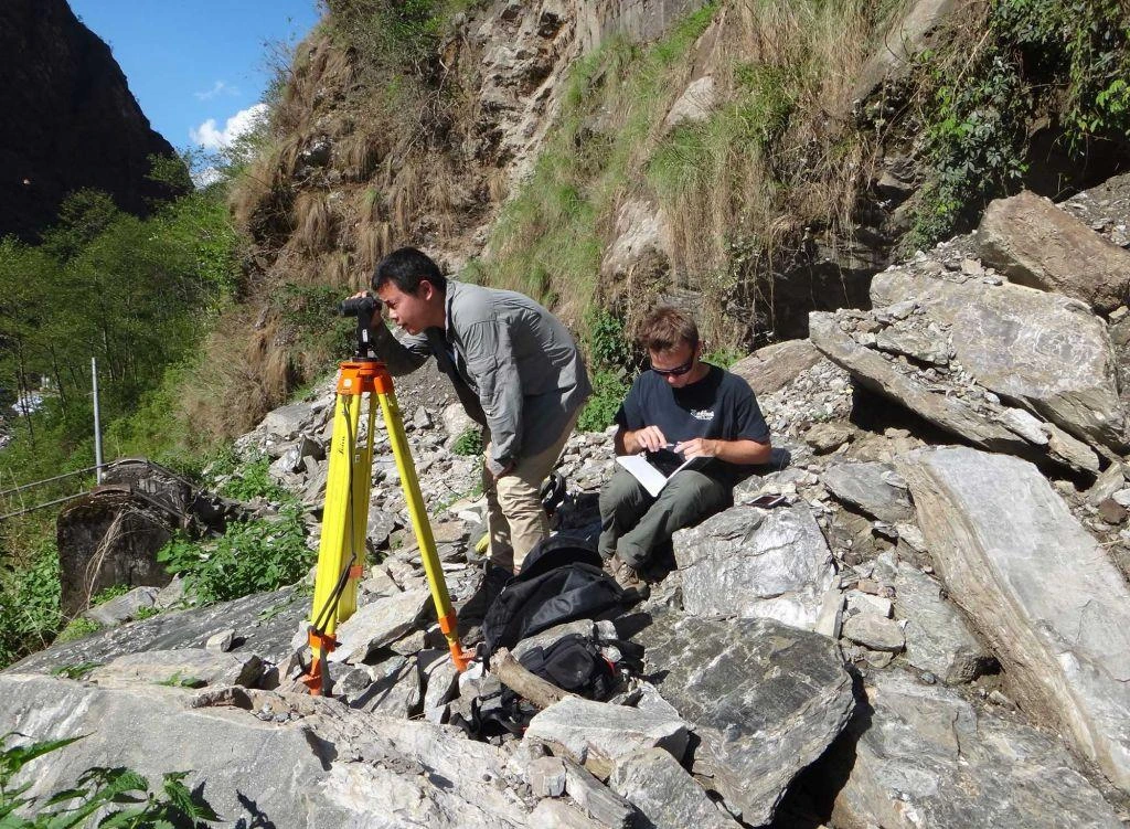
Nepal’s permafrost research community has been consistent about what is missing. Borehole monitoring at a handful of representative sites would convert inference into measurement. Automatic weather stations above 5,000 meters would constrain the climate signal. Repeat surveys of rock glacier movement would show whether creep rates are accelerating.
On the management side, the Sagarmatha landslide study offers something immediately usable: a hazard map that planners can overlay on proposed lodge sites, bridge locations and route realignments. Rebuilding a bridge 200 meters from where it failed is cheap compared to rebuilding it twice.
Local institutions matter here. Sagarmatha National Park, its buffer zone user groups, the municipalities of Khumbu Pasanglhamu, and Sherpa community organizations that have managed grazing, forest and trail access for generations are the bodies that will decide where people build. External hazard science is only useful if it reaches them in a form they can act on.
What This Means for Trekkers
Not panic. Slope hazard in the Khumbu is real but diffuse, and the dominant risks to visitors remain altitude illness, weather and transport. If you want the physiological side of that, read our explainer on what hypoxia does to the brain at altitude.
Practical implications are modest and sensible. Pay attention when guides reroute around a slope. Do not linger below freshly scarred gullies, especially in the afternoon when daytime thaw peaks. Treat monsoon and immediate post-monsoon travel in steep sections with extra care. Accept that trails in this landscape move, and that a route marked on a map from a few years ago may no longer exist on the ground.
If you are planning the walk itself, our Everest Base Camp trek guide covers the route in detail, and our piece on Namche Bazaar explains how the region’s main town works.
Frequently Asked Questions
Is there really permafrost in Nepal?
Yes. Ground temperature measurements going back to 1973, plus resistivity and seismic surveys and the presence of active rock glaciers, confirm permanently frozen ground at high elevations across the Nepal Himalaya. Its lower limit varies by region and slope aspect, broadly between about 4,200 and 5,500 meters.
How much has the permafrost limit risen in the Everest region?
Work by Fukui and colleagues reported a rise from 5,200 to 5,300 meters in 1973 to 5,400 to 5,500 meters by the 1990s, with relative stability afterward. Treat these as the best available estimates from limited data, not as a continuously monitored record.
Does permafrost thaw cause avalanches and rockfall?
It raises the likelihood rather than directly triggering events. Ice binds fractured rock and loose debris. As it thaws, slopes become more sensitive to rainfall, seismic shaking and heat waves. Attributing a specific event to permafrost thaw requires site-level evidence that usually does not exist in Nepal.
Was the 2024 Thame flood caused by permafrost thaw?
No. ICIMOD’s investigation attributed it to a chain-reaction failure of two glacial lakes above the village. Glacial lake outburst floods and permafrost degradation are related symptoms of a warming cryosphere, but they are distinct processes.
Are lodges and bridges in the Khumbu unsafe?
Most are in regular use and functioning. A 2026 modeling study found that a substantial share of buildings, bridges and trail kilometers sit in elevated-hazard zones, which is an argument for hazard-aware siting and maintenance, not for avoiding the region.
Do rock glaciers store useful amounts of water?
They store ice, and in drying high-altitude catchments that store may matter more over time. How much water Nepal’s rock glaciers hold in total has not been reliably quantified, and published national figures should be read as rough estimates.
Why is there so little permafrost data in Nepal?
Cost, altitude and access. Monitoring requires boreholes and instruments maintained for years above 5,000 meters. Funding has historically gone to glaciers, which are easier to measure by satellite and more visible to the public.
Is this changing the trekking routes themselves?
In places, yes. Sections of the Gokyo valley above Phortse have been recognized as unstable since the 1980s, and researchers note that even newer alternative routes cross landslide terrain. Route realignment in the Khumbu is ongoing and largely undocumented in guidebooks.
Further Reading
NepalVue covers the science of Nepal’s mountains alongside the practical guides. Save this piece for your next Khumbu trip, share it with anyone planning one, and follow NepalVue for more reporting on how Nepal’s high country is changing.


