Everyone heads west when they land in Nepal. Pokhara, the Annapurnas, the lakeside cafes that fill up by noon. Yet a small and growing group of photographers, writers, and slow-travel types are quietly doing the opposite, boarding a 40-minute flight in the other direction toward tea hills most foreign visitors have never heard of. Eastern Nepal travel in the monsoon is the kind of trip that sounds backward on paper and makes complete sense the moment you are standing in it.
Here is what most guides will not tell you: the rainy season, the very months everyone tells you to avoid, is when the eastern hills look their absolute best.
Why Eastern Nepal Travel Works in the Monsoon
Most of Nepal’s tourism machine shuts down from June through August. Trekking guides go home, teahouses on the popular routes empty out, and travel blogs paint the whole country as a washout of leeches and canceled flights.
That picture is mostly true for the central and western mountains. It is not the full story in the east.
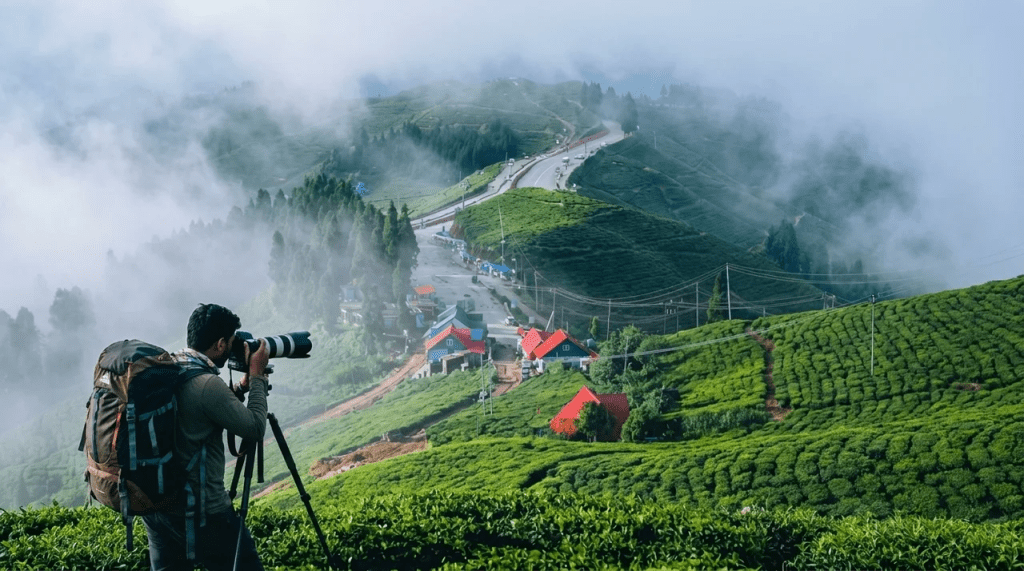
The eastern hills sit at lower elevations than the high trekking corridors, and they catch a gentler, greener kind of rain. Mornings often open clear before clouds roll up from the Terai by early afternoon. Tea bushes that look dusty and tired in spring turn an almost unreal shade of green. For anyone holding a camera, this is the payoff. Mist drifts between rows of tea, prayer flags hang heavy with moisture, and the light goes soft in a way that no dry-season afternoon can match.
There is a practical reason creatives are choosing this region too. Crowds vanish. Prices drop. Homestay hosts who are run off their feet in October have time to sit and talk in July, and that access is worth more than any clear mountain view.
Ilam: The Tea Country That Photographs Like a Dream
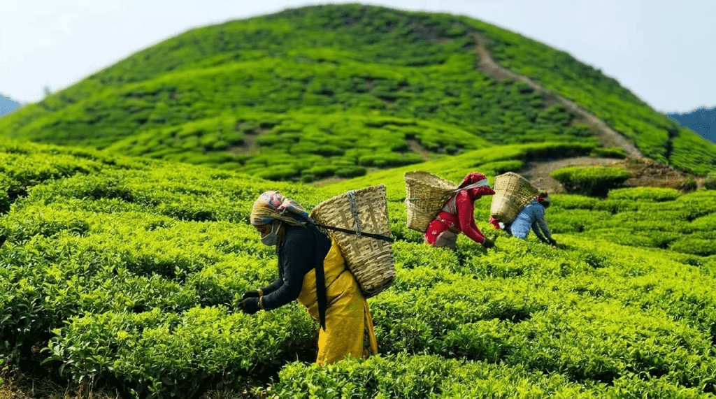
If eastern Nepal has a capital of mood, it is Ilam. Known as the tea heartland of the country, Ilam grows leaf so good it gets compared to Darjeeling just across the Indian border, and the locals will happily argue theirs is better.
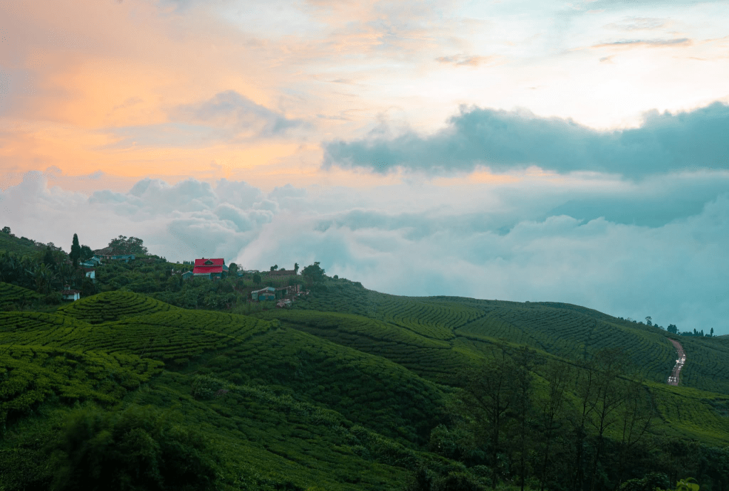
Kanyam is the postcard. Neat rows of tea bushes roll across the hills here, and on a clouded monsoon morning the whole estate seems to float. Walk in early, before the day-trippers from the plains arrive, and you can have entire ridgelines to yourself.
Then there is Antu Danda, locally called Shree Antu, perched at roughly 2,328 meters. On a clear dawn it offers a view that stops people mid-sentence: the flatlands of the Terai far below, waves of tea gardens, and on the horizon the snow wall of Kanchenjunga, at 8,586 meters the third-highest mountain on earth. Cloud cover means you will not get that view every morning in July. When the sky does crack open after a night of rain, though, the scene is sharper and more dramatic than anything the dry months serve up.
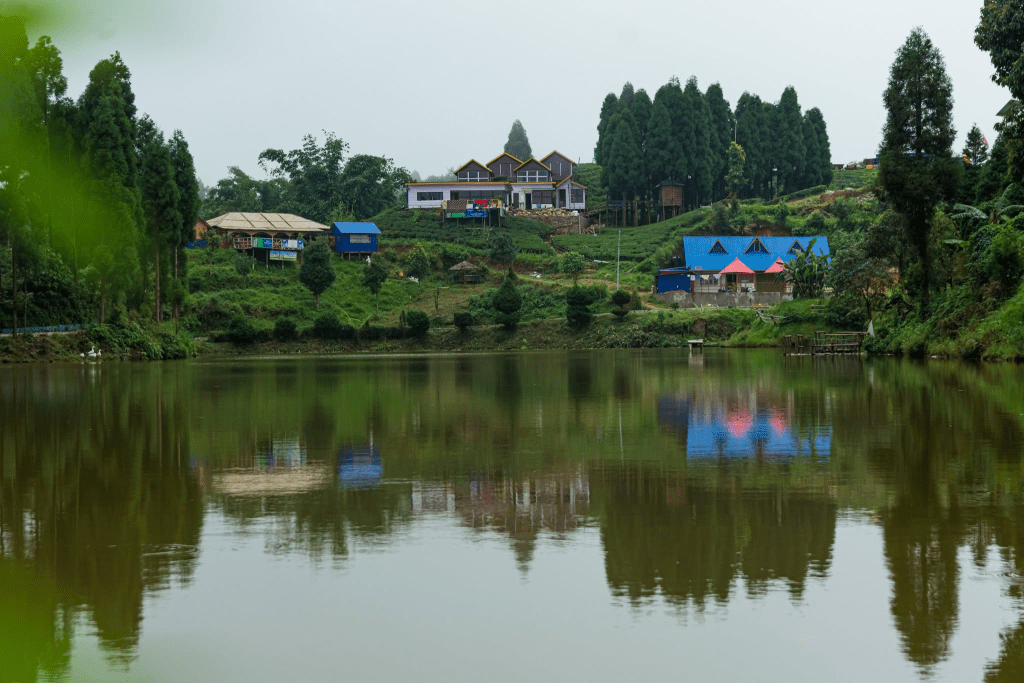
Stay in a community homestay around Shree Antu and you get the other half of the trip. Limbu and Rai families open their homes, cook you dal bhat with greens pulled from the hillside an hour earlier, and pour endless cups of the tea growing right outside. Mai Pokhari, a small sacred lake ringed by forest a short drive away, turns properly mystical in the wet season, all moss and reflection and fog.
Dharan, Dhankuta, and the Hills Above the Plains
Not every traveler wants to commit fully to tea country. Dharan makes a good base for that reason. Sitting where the eastern hills meet the Terai, it pulls together people from Sankhuwasabha, Terhathum, Panchthar, Dhankuta, Bhojpur, Taplejung, and Khotang into one busy, friendly town. You hear half a dozen languages in a single market lane.
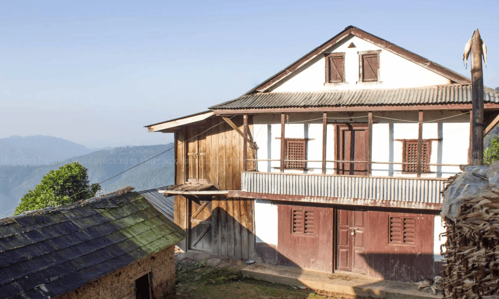
Climb the winding road north and you reach Dhankuta, a tidy hill town with whitewashed houses and a cleaner, cooler feel than almost anywhere in Nepal. Hile, just above it, is famous for cardamom and for a tea-shop culture that has barely changed in decades. Writers love this stretch. Not much happens, and that is exactly the point.
For those who want to push further into wild country, the Arun Valley opens up to the northeast. Often called the deepest valley in Nepal, it runs below the giant Makalu massif and into Makalu-Barun National Park. Phidim, the headquarters of Panchthar, sits as a quiet gateway toward the Kanchenjunga Conservation Area. Serious monsoon trekking up there demands real preparation and a good local guide, but even a short visit to the valley mouths gives you scenery on an enormous scale.
Getting to Eastern Nepal: The Honest Logistics
Distance is the real filter that keeps eastern Nepal quiet. From Kathmandu, you have two basic choices, and the right one depends on your patience.
Flying is the sane option. Buddha Air and Yeti Airlines run multiple daily flights from Kathmandu to both Bhadrapur and Biratnagar, the two eastern gateway airports. Kathmandu to Biratnagar takes about 35 minutes in the air; Kathmandu to Bhadrapur runs roughly 40 to 45 minutes. As of early 2026, one-way fares for foreign travelers were typically in the range of about 60 to 100 US dollars, though prices shift with season and demand, so book ahead in peak weeks. From either airport, Ilam is a few hours uphill by jeep or local bus.
Driving is the cheap, slow, adventurous option. A bus from Kathmandu to the eastern plains can run 10 to 14 hours or more, and in heavy monsoon that number is a guess, not a promise. Landslides close roads. Schedules slip. This is the trade-off of rainy-season travel in Nepal, and it is non-negotiable.
- Build slack into your plan. Add a buffer day or two so a single washed-out road does not wreck the whole trip.
- Fly in, drive out, or the reverse. A mix gives you speed at the front and scenery on the return.
- Travel light and pack for wet. A rain cover for your bag and dry sacks for camera gear matter more here than warm layers.
- Hire local transport at the airport. Shared jeeps to Ilam are cheaper and more flexible than you expect.
For trip planning and current regional information, the Nepal Tourism Board is the official starting point. Lonely Planet’s overview of where to go in Nepal is also useful for fitting the east into a wider route.
Who This Trip Is Really For
Eastern Nepal in the monsoon is not a checklist destination. You will not collect famous peaks or tick off a bucket-list trek. What you get instead is texture: a region where the rain is part of the appeal rather than the enemy, where a tea farmer has time to teach you how the leaf is rolled, and where you can shoot for three days and never see another foreign face.
If your idea of a good trip is a packed itinerary and guaranteed views, go west and go in October. If you would rather wander, wait out an afternoon downpour with a cup of fresh Ilam tea, and come home with images nobody else has, this corner of the country is waiting. The truth is that the best light in Nepal often shows up exactly when the guidebooks tell you to stay home.
Planning a broader rainy-season trip? Our complete guide to Nepal’s monsoon season and our notes on monsoon travel safety on flights and highways are worth reading before you book. And if you still want the classic west, our Pokhara travel guide covers the other side of the country.
Frequently Asked Questions
Is it safe to travel to eastern Nepal during the monsoon?
Generally yes, with caution. Eastern hills get lighter rain than the central mountains, and towns like Ilam and Dhankuta stay accessible most of the season. Your real risk is road disruption from landslides, so build buffer days into your schedule and avoid tight connections.
What is the best month to visit Ilam for tea gardens?
For the greenest, most photogenic gardens, July and August are hard to beat, since the bushes are in full flush and the mist is constant. If you want guaranteed mountain views of Kanchenjunga as well, late September into November offers clearer skies, though with more visitors.
How do I get from Kathmandu to Ilam?
Fly from Kathmandu to Bhadrapur or Biratnagar, which takes 35 to 45 minutes, then take a jeep or local bus a few hours uphill to Ilam. Driving the whole way from Kathmandu is possible but takes well over 12 hours and is unpredictable in heavy rain.
Can I see Kanchenjunga from Ilam?
Yes, on a clear morning. Antu Danda, at around 2,328 meters, is the classic viewpoint for spotting Kanchenjunga, the world’s third-highest peak at 8,586 meters. Cloud cover in the monsoon means views are not guaranteed daily, so plan more than one sunrise if the mountain is a priority.
Are there homestays in eastern Nepal, or only hotels?
Community homestays are one of the highlights of the region, especially around Shree Antu and in villages near Ilam. Limbu and Rai families host guests with home-cooked meals and a genuinely warm welcome. Basic hotels and guesthouses also exist in larger towns like Ilam bazaar, Dharan, and Dhankuta.
Is eastern Nepal good for photographers specifically?
It is one of the most underrated photo regions in the country. Rolling tea estates, layered mist, traditional hill architecture, and dramatic post-rain light give you variety that crowded western destinations cannot match in the wet months. Bring dry sacks and a rain cover for your gear.
How much does a trip to eastern Nepal cost?
It is one of the more affordable parts of Nepal. As of early 2026, return flights from Kathmandu ran roughly 120 to 200 US dollars, homestays often cost a modest amount per night including meals, and local transport is cheap. Your biggest variable expense is usually the flight, so booking early helps.
Do I need a special permit to visit Ilam and the eastern hills?
No special trekking permit is needed for the main tea-tourism areas like Ilam, Kanyam, and Dhankuta, which are open and road-accessible. Restricted and high-altitude zones such as parts of the Kanchenjunga Conservation Area do require permits and a registered guide, so check current rules before heading into those regions.