



Most people assume the 2015 Gorkha earthquake released the pressure built up under Nepal. It did the opposite of settling the question. The Mw 7.8 rupture broke only a limited patch of the fault system, never reached the surface, and left the longest-quiet segments of the Himalayan front still locked. Understanding the Main Frontal Thrust and the fault system it belongs to explains why Nepali seismologists talk about centuries of stored strain rather than a hazard that has passed. This article sets out the mechanism, the measurements, and the honest limits of what geoscience can currently say.
India driving into Asia: the engine
India’s continental plate is moving north into Eurasia. Along the Nepal Himalaya, GNSS measurements published in Earth, Planets and Space in 2024 using data from the NERDiM network show the overriding block moving relative to India at roughly 16.0 to 21.2 mm per year, increasing eastward. Roughly 45 to 54 percent of total India-Eurasia convergence is absorbed as shortening across the Himalaya.
Put simply, Nepal is being squeezed by about two centimeters a year. Over a human lifetime that is more than a meter and a half of shortening that has to go somewhere.


It does not go anywhere smoothly. Most of it accumulates as elastic strain in locked rock, and is released abruptly in earthquakes.
One fault system, several names
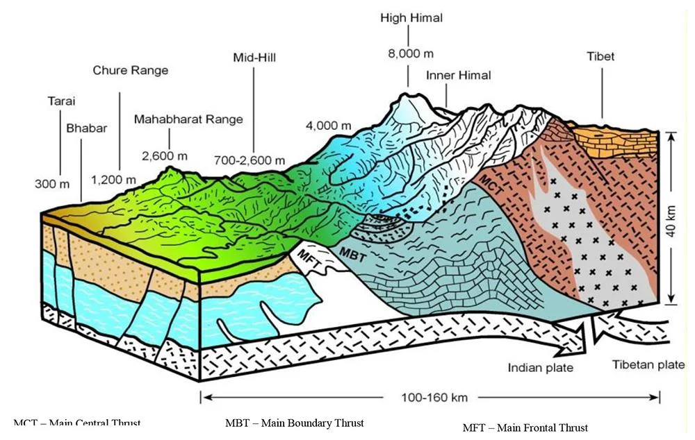
Readers often meet three acronyms and assume they are three unrelated faults. They are parts of one structure.
| Term | What it is | Where you see it |
|---|---|---|
| MHT, Main Himalayan Thrust | The master detachment: the gently dipping surface on which the Himalaya is thrust over the Indian plate | At depth, beneath the entire range |
| MFT, Main Frontal Thrust | The southernmost, youngest surface expression of that detachment | At the boundary between the Siwalik hills and the Terai plain |
| MBT, Main Boundary Thrust | An older frontal structure, now largely inactive but occasionally reactivated | North of the MFT, between Siwalik and Lesser Himalaya |
Think of the MHT as the ramp and the MFT as its front edge where it meets daylight. When a great Himalayan earthquake ruptures the full width of the locked zone, it is the MFT that can break the ground surface and offset river terraces.
Locked, creeping, and the line in between
A fault is “locked” where the two sides are stuck and strain accumulates, and “creeping” where they slide past each other continuously without storing much energy. Coupling describes how stuck a patch is, from 0 to 1.
Geodetic modeling in the 2024 study found coupling on the MHT in Nepal is close to binary, with sharp transitions over narrow zones rather than a gentle gradient. Coupling is nearly complete at shallow depths above about 10 km. Weakly coupled patches appear at intermediate depths of 10 to 20 km. Further down, the fault is decoupled and creeping.
Slip deficit is the useful number: it is how much slip the fault should have accommodated but has not. Depth-averaged to 25 km, the same study reports roughly 18.5 mm per year in eastern Nepal, and about 7.3 to 16.3 mm per year in the west, with 10.4 mm per year adopted for their hazard estimate. Central Nepal falls between the two, larger than the west.66
What the slip deficit adds up to
Multiply slip deficit by fault area, elapsed time and rock rigidity, and you get accumulated seismic moment: the energy budget available to a future earthquake.
Using 679 years since the 1255 event, a 150 km source, 25 km depth and 30 GPa rigidity, the 2024 study estimates about 8.14 x 10²¹ N·m of accumulated moment in eastern Nepal, equivalent to Mw 8.54. Its authors describe that as a likely maximum rather than a prediction. For western Nepal, measured since the 1505 earthquake over a 300 km source, they estimate about 6.98 x 10²¹ N·m, equivalent to Mw 8.50.
Two cautions belong with those figures. First, accumulated moment tells you what is available, not when it will be spent, and not whether it will be spent in one rupture or several. Second, converting moment to a magnitude requires assumptions about rupture dimensions that are themselves uncertain.
Where the risk is judged most urgent
Counterintuitively, the 2024 analysis judges central Nepal the most pressing concern, not the west, because central Nepal combines a long quiet interval with a larger slip deficit rate than the west. Paleoseismic work has identified a complete surface rupture in central Nepal in either 1344 or 1408, with none identified since. Western Nepal’s slower geodetic deficit is consistent with its long quiescence since 1505.
Different research groups weight these factors differently, and the relative ranking of western and central Nepal is genuinely contested in the literature. Readers should treat it as an open scientific question rather than a settled result.
The paleoseismic record: reading broken ground
Instrumental seismology in Nepal covers barely a century. Great Himalayan earthquakes recur over centuries. Trenching across the MFT is how researchers extend the record.
The key paper here is Sapkota, Bollinger, Klinger, Tapponnier, Gaudemer and Tiwari, published in Nature Geoscience in late 2012. Working at the Sir River site in eastern Nepal, they found rupture traces along at least 150 km of the MFT between about 85°50′ and 87°20′ E, and argued that both the 15 January 1934 Bihar-Nepal earthquake (Mw 8.2) and the 7 June 1255 earthquake that devastated Kathmandu broke the surface along the same stretch.
Their conclusion overturned a prior consensus. Great Himalayan earthquakes had been widely treated as blind, meaning they stopped short of the surface. Sapkota and colleagues showed at least two did not, and that two great events 679 years apart, rather than one giant eleventh-century rupture, produced the uplift seen in young river terraces in eastern Nepal.
Not everyone agrees. Wesnousky and co-authors published observations in Geophysical Research Letters in 2018 that disagree with earlier interpretations of 1934 surface rupture along the frontal thrust. Debate over which historical events reached the surface, and over how far they ruptured, remains active. Where you see a confident single number for Himalayan earthquake recurrence, be skeptical.
Why 2015 did not solve the problem
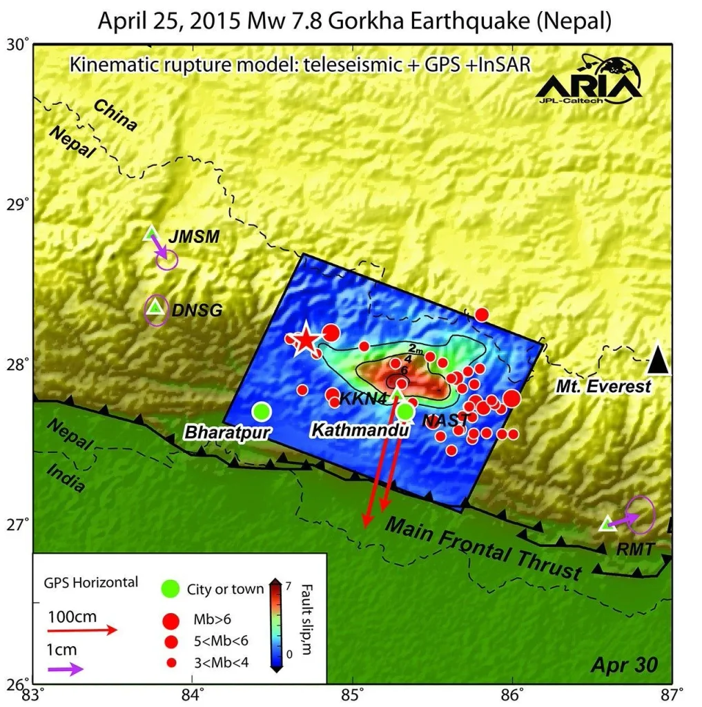
The Gorkha earthquake struck on 25 April 2015 at Mw 7.8, followed 17 days later by a Mw 7.3 aftershock. Close to 9,000 people died and more than 21,000 were seriously injured, making it Nepal’s worst disaster since 1934.
Geologically, three features matter.
- It did not reach the surface. Unlike 1934, the 2015 rupture stopped underground. The shallowest, most strongly coupled part of the fault, the section nearest the MFT, did not break.
- It was comparatively small for the system. Mw 7.8 releases far less energy than the Mw 8.5 class events the accumulated moment calculations describe. Magnitude scales logarithmically, so an Mw 8.5 releases roughly 22 times the energy of an Mw 7.8.
- It broke a limited patch. Gorkha ruptured a section just west of the 1934 event, leaving the long-quiet western and central segments untouched.
Some researchers argue that a rupture which stops short of the surface transfers stress to the shallow section ahead of it, loading rather than relieving the frontal thrust. That mechanism is physically well established in principle. Quantifying it for the Nepal Himalaya is still an area of active work.
What this means for people, not plates
Seismic hazard is what the ground does. Seismic risk is what that does to people, and the second is far more changeable than the first.
Kathmandu’s vulnerability is partly geological. Its basin is filled with soft lake sediments that amplify and prolong shaking, a resonance effect documented in Science after 2015. Valley sediment turns a strong shake into a longer, slower one that is particularly damaging to mid-rise buildings.
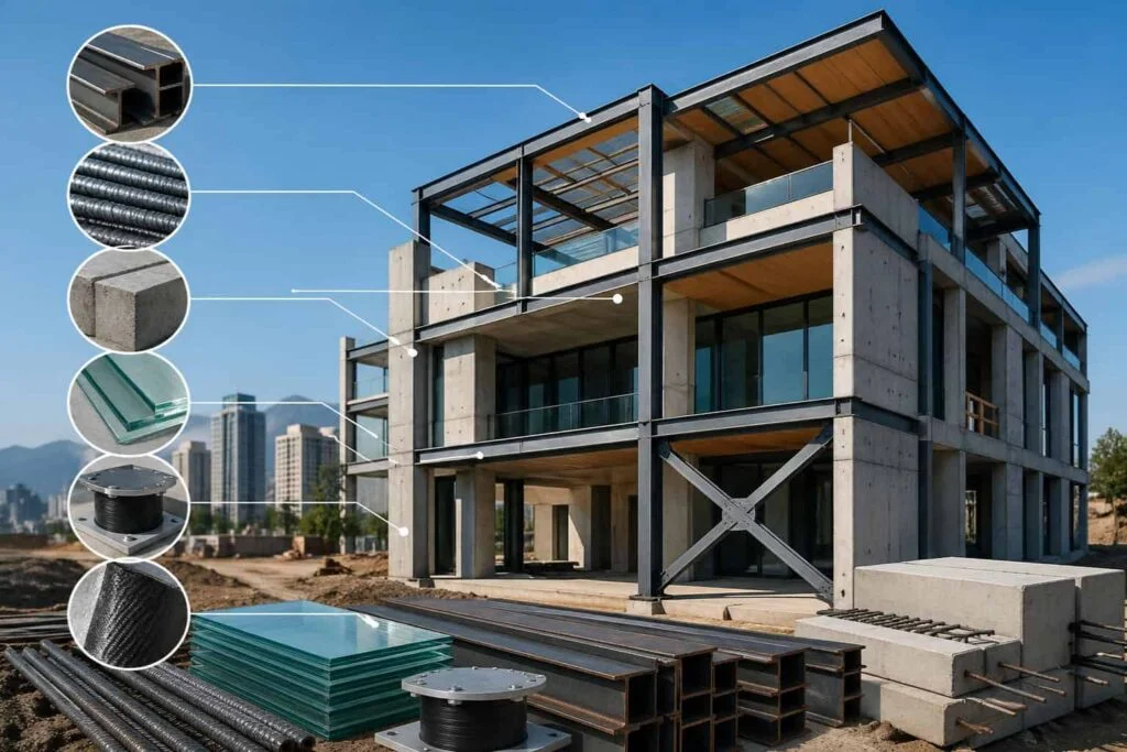
The rest of the risk is built. Construction quality, enforcement of the national building code, school and hospital retrofitting, and whether households know what to do in the first 30 seconds all change outcomes more than any refinement of a slip deficit estimate. Nepal’s reconstruction after 2015 produced hundreds of thousands of rebuilt homes, and the standard they were rebuilt to is the live question for the next event.
For travelers, this is context rather than a reason to stay away. Earthquakes cannot be predicted, and no credible scientist claims otherwise. Knowing how your accommodation is built, and where the exits are, is proportionate. Our guide to UNESCO World Heritage sites in Nepal covers monuments where restoration after 2015 is still visible, and the Kathmandu city hiking guide takes you through the valley rim where the basin’s shape is obvious.
Frequently Asked Questions
What is the Main Frontal Thrust?
It is the southernmost active fault of the Himalaya, where the Main Himalayan Thrust reaches the surface at the boundary between the Siwalik hills and the Terai plain. Great Himalayan earthquakes can break the ground along it.
How fast is India moving into Asia beneath Nepal?
Geodetic measurements give roughly 16 to 21 mm per year of shortening across the Nepal Himalaya, increasing eastward, which is about 45 to 54 percent of total India-Eurasia convergence.
Did the 2015 earthquake release the pressure?
No. The Mw 7.8 Gorkha rupture broke a limited section, did not reach the surface, and left the shallow frontal part of the fault and the long-quiet western and central segments unbroken.
How large could a future Himalayan earthquake be?
Moment accumulation estimates published in 2024 correspond to roughly Mw 8.5 in both eastern and western Nepal. These are estimates of available energy, not forecasts, and depend on assumptions about rupture size.
Can earthquakes in Nepal be predicted?
No. Science can estimate where strain is accumulating and how much, and can describe long-term probabilities. Predicting the date, place and size of a specific earthquake is not currently possible anywhere in the world.
Why is Kathmandu especially vulnerable?
The valley sits on thick soft sediments from an ancient lake, which amplify and lengthen ground shaking. Dense construction and variable building standards add to the risk.
When was the last great earthquake in western Nepal?
1505. No great earthquake has been identified there since, which is why the region is described as a seismic gap. Central Nepal’s last identified complete surface rupture was in 1344 or 1408.
What is the difference between seismic hazard and seismic risk?
Hazard is the expected ground motion from earthquakes. Risk combines that hazard with exposure and vulnerability, meaning how many people and buildings are there and how well they can withstand shaking.
For more on the landscapes this tectonic engine built, see our guide to Everest Base Camp. Save this explainer, share it with anyone who thinks 2015 settled the matter, and follow NepalVue for more reporting on the forces that shape Nepal.


